Coast Guard locates hatch blown off in W-Sapphire explosion
Written by Nick Blenkey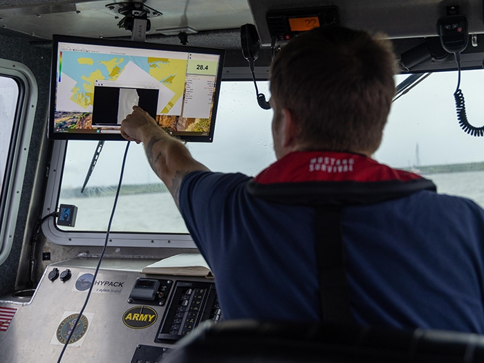
U.S. Army Corps of Engineers Baltimore District Captain Jake Tuer onboard survey vessel BUCK conducts sonar surveys around Baltimore's Fort McHenry Channel on Aug. 19, 2025, in response to an explosion aboard the 751-foot merchant vessel W-Sapphire in Baltimore Harbor on Aug. 18. The data collected during this process will help determine the operational plan moving forward needed to fully reopen the federal channel. [USACE photograph]
In an update released at 7.15 p.m. EDT yesterday on its continuing response to the W-Sapphire explosion, the Coast Guard said that it had located a hatch that had been blown off the coal carrier in the blast.
The Coast Guard has now updated the measures in place to ensure the safety of personnel, vessels, and the marine environment.
After the hatch location was identified, the Coast Guard has made the following adjustments to the measures it had put in place to ensure the safety of personnel, vessels, and the marine environment.
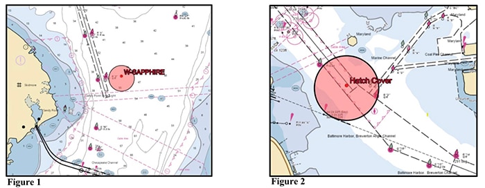
● Discontinuation of safety zone: The safety zone previously established for all navigable waters of the Chesapeake Bay within a 2,000-yard radius of a detached hatch cover at position 39.20692° N, 76.51733° W has been discontinued.
● Intermittent safety zone during recovery operations: An intermittent safety zone will be activated for all navigable waters within a 500-yard radius of the hatch cover at position 39.20865° N, 76.52017° W during dive and salvage operations that are tentatively scheduled for 6:00 a.m. Wednesday morning.
● Active safety zone around vessel W-Sapphire: A 500-yard safety zone remains in effect around the vessel W-Sapphire, anchored at position 39.02333° N, 76.36833° W. Mariners are advised to avoid this area.
● Draft restriction implemented: A draft restriction has been established for vessels transiting within a 500-yard radius of the detached hatch cover, now located at position 39.20865° N, 76.52017° W. Vessels are restricted to a maximum navigational draft of 46.6 feet due to the depth of 49.7 feet at Mean Lower Low Water (MLLW).
Earlier yesterday, the Coast Guard had said that recovery plans to locate and retrieve the hatch were under development, but its exact location and potential impact on the navigable channel remained unknown.
The measures announced at 7.15 p.m. EDT yesterday were as follows:
As a precaution, the Patapsco River has been closed to all vessel traffic between position coordinates 39°11.70’N, 076°31.71’W, near Swan Creek, and 39°12.6’N, 076°29.74’W, near Sparrows Point, and extending up to the former location of the Francis Scott Key Bridge.
Crews are awaiting verification to confirm safe conditions before proceeding with further Coast Guard investigations onboard the vessel.
Additionally, a 500-yard safety zone has been established around where the W-Sapphire is anchored at position 39°01.4’N, 076°22.10’W, north of the Chesapeake Bay Bridge.
The U.S. Army Corps of Engineers deployed the vessel Buck, a sonar-equipped survey vessel, to thet W-Sapphire explosion site at approximately 7:30 a.m. Tuesday. The Buck is collecting data to identify any obstruction s to the safe navigation of traffic entering or exiting the Port of Baltimore via the Fort McHenry Federal Channel. The data will also help determine the operational plan needed to fully reopen the federal channel.
Categories: News