NTSB reports on $258K grounding of towboat Tom Frazier
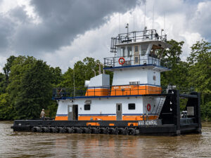
Written by Nick Blenkey![Tom Frazier aground and listing to starboard on Feb. 11, 2024. [Photo: U.S. Coast Guard]](https://www.marinelog.com/wp-content/uploads/2025/06/Towboataground.jpg)
Tom Frazier aground and listing to starboard on Feb. 11, 2024. [Photo: U.S. Coast Guard]
The National Transportation Safety Board (NTSB} has issued its report on a Feb.10, 2024 incident in which the towboat Tom Frazier grounded near Portsmouth, Ohio. The towboat, built in 1979 by Jeffboat and operated by McNational, sustained damage estimated at $258,737. The vessel’s nine crewmembers were safely evacuated to shore. An estimated five gallons of oil were released.
The Tom Frazier had departed Cairo, Ill., February 2, pushing 15 empty hopper barges—arranged in three strings of five barges each—en route to South Point, Ohio, upbound on the Ohio River.
On February 10, at 1830, the tow approached Portsmouth, Ohio, in darkness. Upbound vessels had to transit through two bridges connecting Portsmouth and Greenup County, Ky., coming out of the 90° bend in the Ohio River near Portsmouth: the Carl D. Perkins Bridge at Mile 356.8 and the U.S. Grant Highway Bridge at Mile 355.5.
At 1838, with the captain at the helm, the Tom Frazier successfully transited through the Carl D. Perkins Bridge. As the Tom Frazier tow transited through the U.S. Grant Bridge, the captain contacted the operator of the 113.3-foot-long towing vessel Debi Sharp—which was downbound 1.5 miles away, pushing 25 barges (19 loaded and six empty)—to make passing arrangements. The captain of the Tom Frazier and operator of the Debi Sharp agreed to meet starboard-to-starboard, and, about 1847, the Tom Frazier tow cleared the U.S. Grant Bridge slightly left of the sailing line in preparation for this passing arrangement. Once clear of the U.S. Grant Bridge, the captain of the Tom Frazier maneuvered farther to port toward the right descending bank to give the Debi Sharp more room to maneuver, since the Debi Sharp was downbound making 5.5 mph in a following current.
According to the U.S. Army Corps of Engineers, this location was a common area for upbound vessels to move over to avoid downbound vessels, which have the right-of-way and must line up to navigate the two bridges. About 0.5 miles upriver from the U.S. Grant Bridge, jetties, made of stone, extended out about 55 feet (at datum) from the right descending bank of the river. The jetties, co-located with a boat ramp, protected marinas near the bridge from current and flotsam and were charted. When the Tom Frazier tow passed through the two bridges, the river level was 19.2 feet (at the Portsmouth gage), and the jetties were submerged.
While the Tom Frazier tow was running close to and parallel with the right descending bank, outside the charted 9-foot-depth contour line, about Mile 355, the empty barges passed over the jetties. At 1855, as the captain of the Tom Frazier attempted to maneuver the tow back into the channel while making a speed of about 4 mph, the Tom Frazier grounded on one of the jetties, damaging the vessel’s hull plating, framing, and bulkheads, and flooding several spaces, including the engine room.
The vessel remained aground until refloated by salvors and rising water levels.
Analysis
In its analysis, the NTSB notes:
“Given the nighttime conditions and water level, the jetties would not have been visible.
“Although the jetties were charted on electronic navigation charts and thus were visible on the Tom Frazier’s electronic charting system, the captain did not identify the hazard ahead as he maneuvered the vessel toward the bank to make room for the downbound tow, and the vessel grounded on the jetties.”
Probable Cause
The National Transportation Safety Board determines that the probable cause of the grounding was the captain maneuvering his tow too close to the bank in order to avoid a downbound tow, and not identifying the hazard posed by the charted jetties.
- Download the full NTSB report HERE.
Categories: Inland, Inland and Coastal, News