VIDEO: New Baltimore temporary channel opens
Written by Nick Blenkey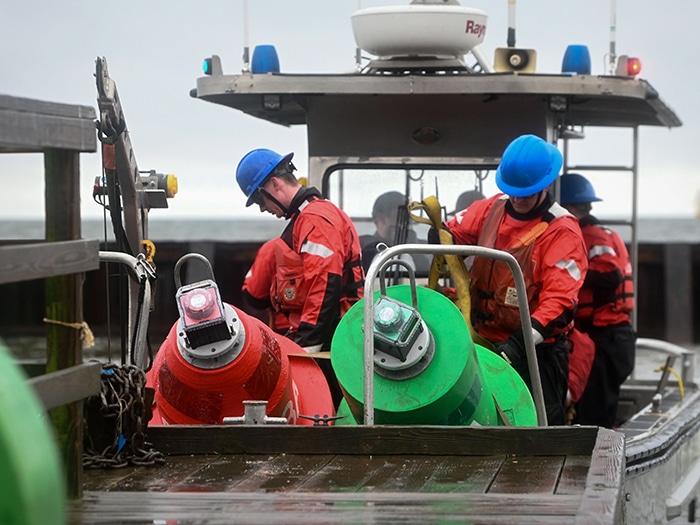
U.S. Coast Guard Aids to Navigation Team (ANT) Baltimore drops buoy channel markers in the Patapsco River in Baltimore, Maryland, April 2, 2024. [USCG Photo]
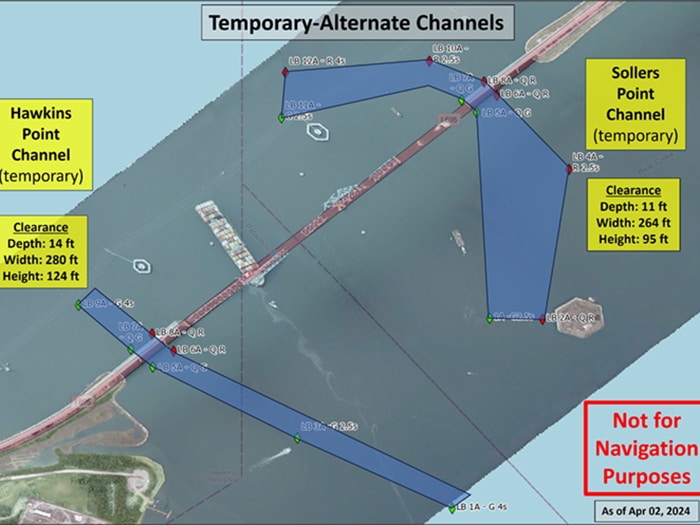
The Unified Command responding to the collapse of Baltimore’s Francis Scott Key Bridge today reported that the Captain of the Port (COTP) has established a second temporary alternate channel on the southwest side of the main channel near Hawkins Point in the vicinity of the Francis Scott Key Bridge for commercially essential vessels.
This action is part of a phased approach to opening the main channel. The second temporary channel is marked with government lighted aids to navigation and will be limited to transit at the discretion of the COTP and during daylight hours only. It has a controlling depth of 14 feet, a 280-foot horizontal clearance, and a vertical clearance of 124 feet.
Established for commercially essential vessels, the channels are suitable for vessels like tugboats and low-draft barges for day use only and with the clearance of the COTP, the two temporary-alternate channels represent a step forward to resuming limited shipping capacity within the Port of Baltimore.
“The opening of these two alternate channels and transit of critical response resources, as well as the first commercial traffic movements through the area, is a significant milestone in our response efforts,” said U.S. Coast Guard Cmdr. Baxter Smoak, operations section chief of the Key Bridge Response 2024. “Our number one priority remains the opening of the deep draft channel. We are simultaneously focused on opening additional routes of increased capacity as we move forward.”
CHALLENGES
While the opening of the two alternate channels is a hopeful sign, it is becoming increasingly clear that full reopening of the Port of Baltimore may be yet a while away. The USACE has released imagery, supplied by the U.S. Navy’s Naval Sea System Command (NAVSEA) Supervisor of Salvage and Diving (SUPSALV), that shows the wreckage resting at the bottom of the river where the Francis Scott Key Bridge once stood.
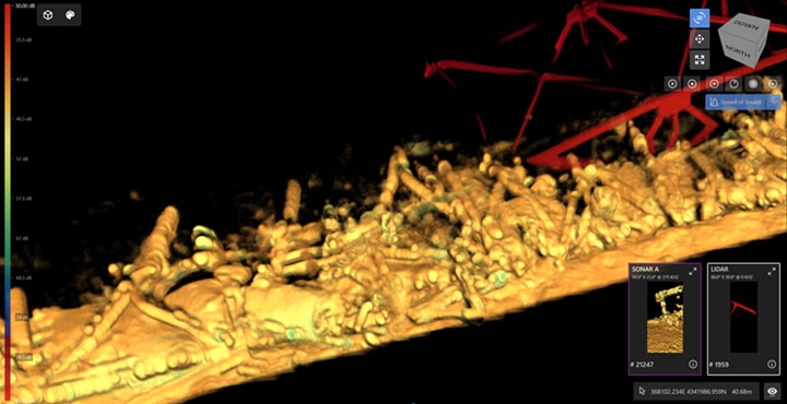
These 3D images show the sheer magnitude of the very difficult and challenging salvage operation ahead. The underwater sonar imaging tool, known as CODA Octopus, is the primary survey tool used by divers, with visibility clouded to just one to two feet because of the four to five feet of mud and loose bottom of the Patapsco River.
Divers are forced to work in virtual darkness, because when lit, their view is similar to driving through a heavy snowfall at night with high-beam headlights on. So murky is the water, notes the Corps, that divers must be guided via detailed verbal directions from operators in vessels topside who are viewing real-time CODA imagery. No usable underwater video exists of the wreckage, because as one Navy diver stated, “there’s no need take video of something you can’t even see.”
Categories: Ports & Terminals, Safety and Security, Salvage, Shipping
![Leatherman Terminal [Photo: SC Ports]](https://www.marinelog.com/wp-content/uploads/2026/06/leathereman-300x225.jpg)

![Secretary Duffy was joined by Great Lakes St. Lawrence Seaway Development Corporation Administrator Mike McCoshen, port leadership and Indiana Transportation Secretary Matthew Ubelhor. [Photo: Ports of Indiana]Secretary Duffy was joined by Great Lakes St. Lawrence Seaway Development Corporation Administrator Mike McCoshen, port leadership and Indiana Transportation Secretary Matthew Ubelhor. [Photo: Ports of Indiana]](https://www.marinelog.com/wp-content/uploads/2026/06/Group-photoduffytour-300x225.jpg)