NTSB reports on barge collision with a coal train
Written by Nick Blenkey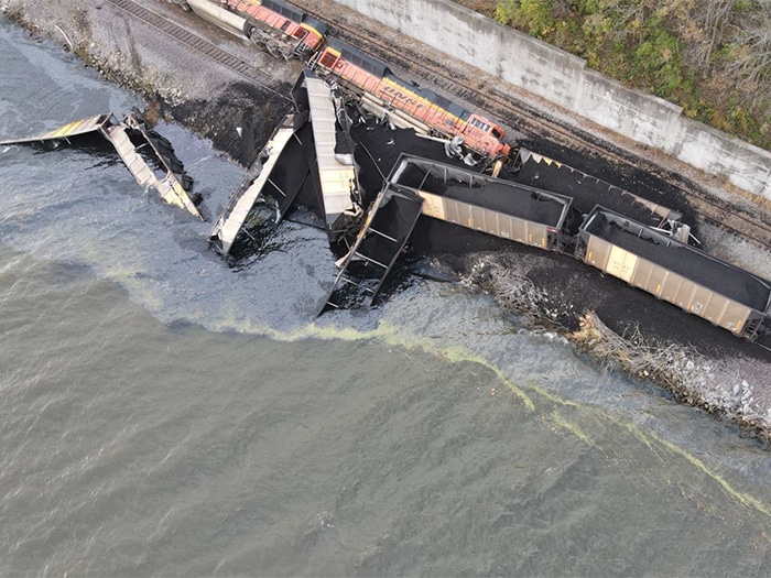
Aerial photo of the derailment of the two locomotives and eight hopper cars. Two additional hopper cars are submerged in the river. Source: BNSF)
A failure by a towboat’s pilot and captain to correctly identify a caution area on an electronic chart is seen by the National Transportation Safety Board (NTSB) as the probable cause of a collision between a tow of four empty barges and a coal train.
NTSB Marine Investigation Report 22/22 details the NTSB’s investigation into the November 13, 2021, collision between a tow pushed by the Southern Towing Company vessel Baxter Southern and a BNSF coal train transiting the track along the shoreline of the Upper Mississippi River. The train struck a barge that was overhanging the railroad track. Two locomotives and 10 hopper cars loaded with coal derailed. Six of the derailed hopper cars entered the river. Two train personnel sustained minor injuries. The collision resulted in $1.9 million in damages to the locomotive and freight cars. The barge sustained minor scrapes.
During a transit downriver, strong wind gusts made the situation unsafe for the Baxter Southern to continue the voyage as planned. Using the vessel’s electronic chart system (ECS), the captain and pilot identified a location on the riverbank that they believed represented a fleeting area safe to push up against. Neither the pilot nor the captain clicked an exclamation point symbol on the electric chart, which would have showed that the area presented a “Railroad Collision and Trackbed Erosion Risk.”
The pilot pushed the tow onto the riverbank, and three crewmembers headed forward on the tow to verify the forward-most barge was clear of the track. While the barge did not cross over either rail, it extended about a foot over the railroad ties.
When the pilot of the Baxter Southern saw the light of the approaching train, he attempted to move the tug and tow away from the riverbank. The train’s engineer activated the train’s emergency brake when the train was about 300 feet from the barge. With only seconds to respond, the activation of the train’s emergency brake and the attempt to move the tow occurred too late to avoid the collision.
ELECTRONIC CHART SYSTEM
The full report goes into more detail about the use of the electronic chart system.
“Both the captain and pilot told investigators that they believed the magenta dashed line as seen on the electronic chart in Rose Point indicated a fleeting area because the pilot said that he had previously seen other towing vessels and barges against the shore in the general area of Mile 372 (a review of automatic identification system data provided by Southern Towing Company to investigators showed that other towing vessels and barges possibly had pushed up against the shoreline in this area over a six-month time frame before the casualty).
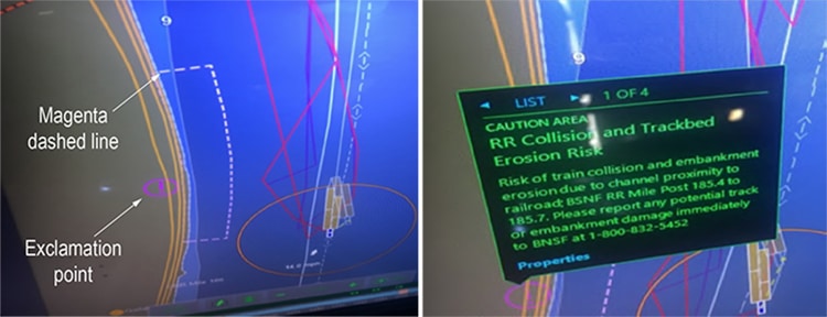
“Next to the magenta dashed line near Mile 372 on the electronic chart was an exclamation mark icon, which indicated that the area within the magenta dashed line was a ‘Caution Area’ according to the ECS symbol reference table. On ECS navigational charts, magenta dashed lines with an exclamation mark show the limit of a caution area where mariners should be “made aware of circumstances influencing the safety of navigation”; there are no navigational chart symbols for a fleeting area. In Rose Point, a user could learn more information about the caution area by selecting the exclamation mark via “cursor pick” (moving the mouse pointer over the area and clicking the right button of the mouse) to read the corresponding caution note. When the exclamation mark icon next to the magenta dashed line near Mile 372 was selected, a box displayed the following information: ‘Caution Area: RR [Railroad] Collision and Trackbed Erosion Risk’ and ‘Risk of train collision and embankment erosion due to channel proximity to railroad.’ Both the captain and pilot said they had training in using the ECS, but they stated they did not see the exclamation point icon by the magenta dashed line because the screen setting was in nighttime mode, making the exclamation point difficult to see.”
WEALTH OF INFORMATION
“ECS provide a wealth of navigation information to mariners,” says NTSB.
“Electronic charting display and information systems (ECDIS) enables users to obtain more information about a feature by querying through a cursor pick,” the report said. “There are many features—including warnings and other navigation information—that can be obtained through a cursor pick that are not specifically noted in the default chart display. Mariners should ensure they understand all symbols and applicable advisories identified in their ECS, and owners and operators should ensure that their crews are proficient in the use of ECS.”
Categories: Inland, News, Safety and Security