TOTE settles with five El Faro families
JANUARY 27, 2016 — As the Coast Guard announced the dates for the first public hearing into the loss of the El Faro, news broke that TOTE Maritime had reached settlements with
JANUARY 27, 2016 — As the Coast Guard announced the dates for the first public hearing into the loss of the El Faro, news broke that TOTE Maritime had reached settlements with
JANUARY 4, 2016 — As part of its continuing investigation into the sinking of the U.S.-flagged cargo ship El Faro in the Atlantic Ocean last October, the National Transportation Safety Board has
“Over the years we’ve completed many investigations without the aid of recorders and other investigative tools,” said NTSB Chairman Christopher A. Hart. “While it is disappointing that the voyage data recorder was not located, we are hopeful that we’ll be able to determine the probable cause of this tragedy and the factors that may have contributed to it.”
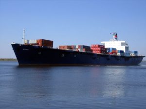
The 790-foot U.S.-flag ship operated by TOTE Maritime Puerto Rico went missing on Oct. 1 during Hurricane Joaquin and was located on Oct. 31 in about 15,000 feet of water in the vicinity of its last known position near Crooked Island, Bahamas.
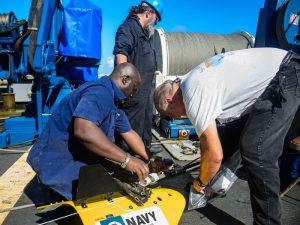
In early October, the NTSB contracted with the U.S. Navy to locate the missing ship, document the wreckage and debris field, and if possible, recover the voyage data recorder.
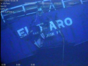
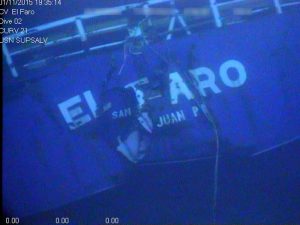
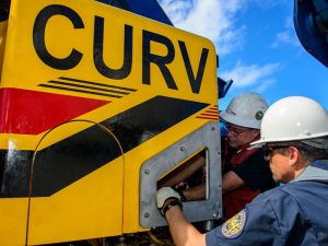
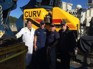
Sonar equipment towed from USNS Apache detected what was believed to be El Faro on Oct. 31. The finding was confirmed on Nov. 1 when investigators were able to view video of the vessel obtained from CURV-21, a remotely operated vehicle capable of deep sea search activity.
Video revealed that the navigation bridge structure and the deck below it had separated from the ship. The missing structure included the mast and its base where the voyage data recorder was mounted.
On Nov. 11, the navigation bridge was found but neither the mast nor the VDR was found in the vicinity of the navigation bridge structure.
After five more days of searching with CURV-21, it was determined that the VDR could not be located. The search and video documentation efforts of El Faro were completed on Nov. 15.
The main wreckage of the TOTE cargo ship that went missing during Hurricane Joaquin was found by a search team on board the U.S. Navy tug USNS Apache on October 31, located at a depth of about 15,000 feet in the vicinity of the last known position near the Crooked Islands in the Bahamas.However, the bridge deck had become separated and the search for it — and the VDR — has continued since then.

The Shipowners’ Limitation of Liability Act sets a formula for the amount at which total claims can be capped and yesterday, Judge Schlesinger ordered the vessel’s insurer, Steamship Mutual Underwriting Association Limited, to pay into court $15.3 million as surety for that amount, calculated as the value of the vessel (which is now zero), pending freight which is $2,072,703.50, and $420 per gross registered ton funds ($13,236,300) for death claims.
He also ordered that all claims in relation to the case must be filed in the U.S. District Court for the Middle District of Florida by December 21, 2015 and that any other actions “be hereby restrained, stayed, and enjoined until the hearing and determination of this action.”
A footnote to the ruling said, in part, “The Court notes the rarity of issuing an injunction when the Court has only heard from one side of a case. The admiralty rules are unique and call for such a situation.”
Read Judge Schlesinger’s order HERE

The NTSB said yesterday that the Curve 21 remote operated vehicle (ROV) was used to identify the wreck found off the Bahamas at a depth of about 15,000 feet as that of the TOTE ship that went missing on October 1 during Hurricane Joaquin.
The NTSB has contracted with the U.S. Navy to locate the El Faro, document the wreckage and debris field and recover the voyage data recorder (VDR).
The Curve 21 ROV documented both the port and starboard sides of the vessel.
The vessel is oriented in an upright position with the stern buried in approximately 30 feet of sediment.
The navigation bridge and the deck below have separated from the vessel and have not been located. The team has reviewed sonar scans of the nearby debris field and has not identified any targets that have a high probability of being the missing navigation bridge structure.
The voyage data recorder has not been located.
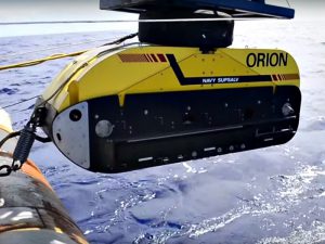
Future plans are to redeploy the Orion side scan sonar system to generate a map of the debris field to locate the navigation bridge structure.

Among the most recent suits filed was one brought by relatives of five Polish members of a riding crew that was aboard the ship when it was lost.
One hurdle facing all these suits is that of the Shipowners Limitation of Liability Act of 1851.
Essentially it allows a shipowner to limit its liability for a casualty to the value of the vessel and the freight then pending, if any. Shipowners are entitled to limit their liability if any negligence or unseaworthy condition that caused the loss occurred without the privity and knowledge of the owner.I n personal injury and death claims, the knowledge of the master of a seagoing vessel at or prior to the commencement of a voyage is deemed to be the knowledge of the owner.
The TOTE companies have moved rapidly to assert this limitation of liability, filing suit in U.S. District Court in Jacksonville, FL on October 30.
You can read the filing HERE
NOVEMBER 1, 2015—The U.S. National Transportation Safety Board reports that a search team on board the U.S. Navy tug USNS Apache has found the wreckage of a ship that they believe to be
The second stage of the search will now start, attempting to find the vessel using side scan sonar.
The USNS Apache arrived at the last known position of the El Faro on October 23, and began searching for the vessel with a Towed Pinger Locator (TPL).
The search area consists of a 10 nautical mile by 15 nautical mile area, in which the USNS Apache towed the TPL on five search lines across the search area in order to detect the acoustic signal associated with the El Faro’s pinger.
The USNS Apache concluded the first phase of the pinger locator search on October 26, 2015, with negative results.
The NTSB says that the TPL’s ability to detect the El Faro’s pinger may be affected by the orientation of the vessel as it lays on the sea floor or the current condition and functionality of the pinger.
The second phase of the search began yesterday, using the Orion side-scan sonar system. The second phase of the search will be conducted over the same search area. This phase will consist of 13 search tracks and will take about 14 days to complete. The side scan sonar system will be used to locate the El Faro, and if found, create an image of the vessel.
If the ship is found on the sea floor, its Voyage Data Recorder or “black box” can be retrieved to help investigators determine the El Faro’s final moments. It is suspected that the ship sank in Hurricane Joaquin on October 1 and is lying on the sea bottom in 15,000 feet of water near the Crooked Islands in the Bahamas. All 33 onboard are presumed lost.
On February 13, 2015, El Faro successfully completed the American Bureau of Shipping (ABS) class and statutory surveys, meeting all rules and regulations as applicable. All deficiencies identified were rectified prior to completion of the surveys. None of the deficiencies were associated with El Faro’s main propulsion systems.
The annual inspection of El Faro, required by the United States Coast Guard (USCG), was completed by qualified USCG inspectors in San Juan, Puerto Rico, on March 6, 2015.
In June 2015, a qualified ABS surveyor examined and tested the main, auxiliary and emergency systems as part of the continuous machinery survey program and found them to be satisfactory.
TOTE told investigators that El Faro was scheduled to be removed from the route between Jacksonville and San Juan and redeployed to the U.S. West Coast where it would operate between Washington State and Alaska. In August, in order to prepare for this operational change, TOTE began to make modifications to the vessel while underway under the supervision of an additional chief engineer. Work on these modifications was performed by welders and machinists over many voyages, including during the accident voyage.
On September 11, 2015, TOTE received permission from the Coast Guard to shut down one of the ship’s two boilers so it could be inspected by an independent boiler service company during a voyage between San Juan and Jacksonville. As a result of the inspection, the boiler service company recommended service to both boilers during an upcoming drydock period that had already been scheduled for November 6, 2015. The boiler was returned to service following the inspection.
Interviews of relief crew and company management indicated that onboard safety drills were consistently conducted on a weekly basis. These included lifeboat drills for all crewmembers to ensure that all on board understood their responsibilities in an emergency.
Investigators interviewed two pilots that had guided El Faro in and out of the Port of Jacksonville; both reported that the vessel handled similarly to other vessels of its size and type.
The vessel’s terminal manager reported that El Faro met stability criteria when it left Jacksonville.The company’s procedures called for some cargo on the ship to be “double lashed” regardless of the weather expected to be encountered during the voyage. The vessel stevedores reported that prior to El Faro’s departure on the accident voyage, the cargo was secured in accordance with those procedures.
Before El Faro departed Jacksonville, Tropical Storm Joaquin was predicted to become a hurricane and a marine hurricane warning was issued by the National Hurricane Center’s Advisory #8 at 5:00 pm EDT on Sept. 29.
At about 8:15 pm EDT on Sept. 29, El Faro departed Jacksonville, Fla., for San Juan, Puerto Rico.
At 1:12 pm EDT on Sept. 30, the captain emailed a company safety official that he intended to take a route south of the predicted path of the hurricane and would pass about 65 miles from its center.
In an advisory issued at 2:00 am EDT on Oct. 1, the National Hurricane Center predicted seas of 30 feet with sustained winds of 64 knots (74 mph), increasing to 105 knots (121 mph) as the El Faro approached the wall of the eye of the hurricane.
In a recorded satellite phone call to the company’s emergency call center at 7:00 am EDT, the captain told the call center operator that he had a marine emergency. He reported that there was a hull breach, a scuttle had blown open, and that there was water in hold number 3. He also said that the ship had lost its main propulsion unit and the engineers could not get it going. The operator then connected the captain with the Designated Person Ashore (DPA). The DPA told investigators that the captain had communicated similar information to him that was provided to the call center operator, and also that the captain had estimated the height of the seas that El Faro was encountering to be 10 to 12 feet.
The USCG received electronic distress alerts from three separate sources on El Faro: the Ship’s Security Alert System (SSAS), the Inmarsat-C Alert, and the Emergency Position Indicating Radio Beacon (EPIRB).
According to electronic alert system data sent by the vessel at 7:17 am EDT on Oct. 1, its last reported position was about 20 miles from the edge of the eye of the hurricane.
The USCG did not have direct voice communications with El Faro, only electronic distress alerts.
The NTSB investigators that traveled to Florida have returned to continue work on the investigation from NTSB headquarters in Washington.
The NTSB contracted with the U.S. Navy to locate the ship, document the wreckage on the sea floor and recover the voyage data recorder.
The USNS Apache, a fleet ocean tug, was outfitted with specialized equipment for this mission, and departed Little Creek, Virginia, at about 4:30 pm EDT on October 19. In addition to the Navy crew, the NTSB investigator-in-Charge, Tom Roth-Roffy, is on Apache with representatives from the USCG, TOTE and ABS, all parties to the NTSB investigation.
The Apache is estimated to arrive at the last known position of El Faro on Saturday, October 24, to begin the search for the ship and to recover the voyage data recorder. Once the search operation begins, it is expected to take at least two weeks.
The length of the operation will depend on the circumstances encountered.Updates on the search for the vessel and the accident investigation will be issued as circumstances warrant.