River water level to be lowered for Lock and Dam 1 repairs
Written by Marine Log Staff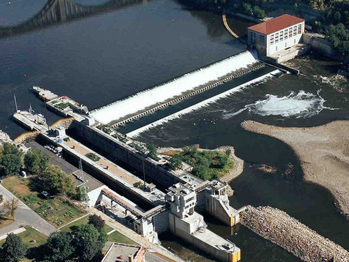
Navigation will remain open during Lock and Dam 1 maintenance period. [USACE photograph
The U.S. Army Corps of Engineers, St. Paul District, and the Minnesota Department of Natural Resources, plan to slightly lower the Mississippi River between Lower St. Anthony Falls and Lock and Dam 1, both in Minneapolis, starting June 24.
Corps officials plan to maintain the lower river elevations through July 7, to inspect and repair the rubber dam on top of the spillway at Lock and Dam 1. To access the rubber dam, the water levels will be lowered approximately one foot below the spillway crest for approximately two weeks. Once the repairs are complete, the normal water levels are expected to be restored no later than July 9. Navigation will remain open to the public during maintenance.
The St. Paul Engineer District is responsible for supporting inland navigation by managing 13 locks and dams and by maintaining the 9-foot navigation channel from Minneapolis to Guttenberg, Iowa.
Lock and Dam 1 fast facts
- Located on Mississippi River mile 847.9, in the city of Minneapolis.
- Construction completed in 1917, reconstructed in 1929. The main lock was completed in May 1932. The last major rehabilitation occured between 1978-1983.
- The dam consists of an Ambursen concrete overflow structure 574-feet long.
- The hydro power station is owned and operated by Brookfield Power Co.
- The lock chamber is 56 feet wide by 400 feet long. It is the only twin lock in the district.