
BOEM paves the way for U.S. East Coast seismic
Written by Nick Blenkey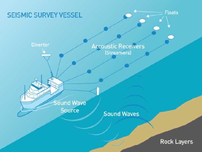
JULY 21, 2014 — The Obama administration has set the stage for companies to start seismic surveys off the U.S. East Coast.
After what it terms “a transparent and robust public process,” the Bureau of Ocean Energy Management (BOEM) Friday issued a Record of Decision (ROD) establishing “the highest practicable level of mitigation measures and safeguards to reduce or eliminate impacts to marine life while setting a path forward for appropriate geological and geophysical (G&G) survey activities off the Mid- and South Atlantic coast to update 40-year old data on the region’s offshore resources.”
The ROD does not authorize any G&G activities. It establishes a framework for additional mandatory environmental reviews for site-specific actions and identifies broadly-applicable measures governing any future G&G activities in the region.
As new scientific information becomes available, these additional findings can be incorporated into the survey-specific environmental reviews through an adaptive management approach.
BOEM will monitor implementation of these mitigations and, if warranted, will modify them.
“After thoroughly reviewing the analysis, coordinating with Federal agencies and considering extensive public input, the bureau has identified a path forward that addresses the need to update the nearly four-decade-old data in the region while protecting marine life and cultural sites,” said Acting BOEM Director Walter D. Cruickshank. “The bureau’s decision reflects a carefully analyzed and balanced approach that will allow us to increase our understanding of potential offshore resources while protecting the human, marine, and coastal environments.”
BOEM’s preferred alternative, which was presented in a Programmatic Environmental Impact Statement (PEIS) released in February, includes the most protection for environmental and cultural resources of the alternatives considered consistent with moving forward with survey activity.
Mitigation measures include vessel strike avoidance measures, special closure areas to protect the main migratory route for the highly endangered North Atlantic Right Whale, consideration of geographic separation of simultaneous seismic airgun surveys, and Passive Acoustic Monitoring to supplement visual observers and improve detection of marine mammals prior to and during seismic surveys.
BOEM will consider permit applications or other proposed authorizations for G&G activities throughout the Mid-Atlantic and South Atlantic Planning Areas, consistent with the mitigation measures set forth in the PEIS for the Preferred Alternative. These Planning Areas extend from the Delaware Bay to just south of Cape Canaveral and from the inner edge of Federal waters along that coastline to 403 miles offshore. The activities covered include G&G surveys undertaken for potential marine minerals, renewable energy and oil and gas resources.
The PEIS assessed G&G activities conducted under BOEM’s marine minerals, renewable energy and oil and gas programs through 2020, including deep-penetration and high-resolution seismic surveys, electromagnetic surveys, magnetic surveys, gravity surveys, remote-sensing surveys and geological and geochemical sampling.
State-of-the-practice G&G data and information are used to identify sand and gravel resources suitable for coastal protection and restoration, site renewable energy installations, and locate oil and gas resources.
G&G activities also provide specific information about the location of shallow hazards, cultural resources, and benthic communities so that these areas can be avoided during any bottom-disturbing activities.
The Notice of Availability of the ROD will publish in the Federal Register on July 22. The ROD is available for review HERE
Categories: Oil & Gas


Leave a Reply
You must be logged in to post a comment.