![Around 11,000 seafarers are to be evacuated from the Strait of Hormuz region under an IMO evacuation plan. [Image: IMO]](https://www.marinelog.com/wp-content/uploads/2026/06/Hormuz-PB_inside-pic-C_medium-300x225.jpg)
StormGeo offers new versions of route optimization system
Written by Marine Log Staff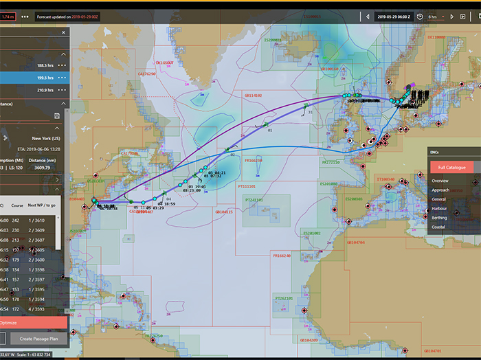
Screenshot from ECDIS display shows three potential routes. One is optimized for shortest distance, identified by light blue way points. The weather layer displays significant waves. Also shown are complete Electronic Nautical Charts (ENC) for the voyage
Weather intelligence and routing specialist StormGeo has launched new versions of its best-selling route optimization system, BVS: NaviPlanner BVS and NaviUpdate.
NaviPlanner BVS simplifies the process of planning and optimizing a route, obtaining the appropriate charts and creating a voyage plan—without switching between different products.
NaviUpdate connects NaviPlanner securely to the ECDIS for direct transfer of routes and charts.
This addresses a major challenge in the shipping industry—the lack of connectivity between voyage planning, route optimization solutions and shore-based decision-making that impacts operational and fuel efficiencies.
“We are addressing customer feedback to simplify ship-to-shore communication. This increases the amount of optimized routes that are actually sailed, improves visibility and transparency between shore-based operations and vessels, and reduces potential cyber threats,” said Svein Kåre Giskegjerde, StormGeo VP of Shipping. “Today, BVS is used by approximately 6,000 vessels. With the added functionality of NaviPlanner BVS and NaviUpdate, StormGeo expects this number to double.”
Categories: News, Technology
![Secretary Duffy was joined by Great Lakes St. Lawrence Seaway Development Corporation Administrator Mike McCoshen, port leadership and Indiana Transportation Secretary Matthew Ubelhor. [Photo: Ports of Indiana]Secretary Duffy was joined by Great Lakes St. Lawrence Seaway Development Corporation Administrator Mike McCoshen, port leadership and Indiana Transportation Secretary Matthew Ubelhor. [Photo: Ports of Indiana]](https://www.marinelog.com/wp-content/uploads/2026/06/Group-photoduffytour-300x225.jpg)
![John Denholm: “Our industry continues to navigate geopolitical tensions, security threats, rapid technological change, the energy transition, and evolving trading patterns.” [Screengrab from Vimeo]](https://www.marinelog.com/wp-content/uploads/2026/06/Denhol-300x225.jpg)