Recovering El Faro VDR requires new mission
Written by Nick Blenkey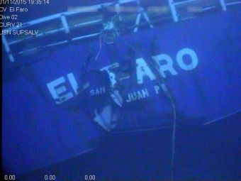
APRIL 28, 2016 — The National Transportation Safety Board says that the investigative team aboard the research vessel Atlantis who located the El Faro’s voyage data recorder Tuesday has determined it will not be possible to recover the VDR during the current mission.
The team of investigators and scientists aboard Atlantis collaborated with investigators at the National Transportation Safety Board lab in Washington and determined that given the VDR’s proximity to the mast and other obstructions, recovery of the VDR cannot be accomplished with the equipment currently available on the ship.
Video and photographic images revealed that the VDR appears to remain attached to a steel beam connected to the mast structure.
“Now that we have been able to see just how the VDR is oriented relative to the mast structure, it’s clear that we’re going to need specialized deep-water salvage recovery equipment in order to bring it up,” said Brian Curtis, Acting Director of the NTSB Office of Marine Safety. “Extracting a recorder capsule attached to a four-ton mast under 15,000 feet of water presents formidable challenges, but we’re going to do everything that is technically feasible to get that recorder into our lab.”
Although there is not yet a confirmed timeframe for the launch of the VDR retrieval effort, investigators are hopeful that the logistics can be coordinated so that the mission can be completed in the next several months.
The current mission will continue to gather imagery of the El Faro hull and debris field until successfully completed. Atlantis is expected to depart the site April 30 and arrive in Woods Hole, Massachusetts, May 5.
The 790-foot, U.S.-flagged, TOTE cargo ship sank October 1, 2015, during Hurricane Joaquin while sailing from Jacksonville, Florida, to San Juan, Puerto Rico. All 33 aboard perished in the accident.
In October and November of 2015, the NTSB conducted an initial search mission to locate the sunken vessel and conduct an initial survey of the debris field. The data collected during that mission were used by investigators to plot “high probability” search zones for the current mission. Those data proved reliable and resulted in the location of the mast and VDR in one of the zones.

Categories: News
![Scillionian IV at the Piriou shipyard in Vietnam. [Photo: Isles of Scilly Steamship Group]](https://www.marinelog.com/wp-content/uploads/2026/07/C439-launching-53-300x225.jpg)
![Sleipnir [Photo: Heerema Marine Contractors]](https://www.marinelog.com/wp-content/uploads/2026/07/sleipniratsea-300x225.jpg)
Leave a Reply
You must be logged in to post a comment.