
NOAA commissions SWATH that it towed from shipbuilder
Written by Nick Blenkey JUNE 11, 2012 — NOAA last week commissioned the coastal mapping vessel, NOAA Ship Ferdinand R. Hassler, during a ceremony at its Marine Operations Center-Atlantic in Norfolk, Va.
The vessel was ordered from VT Halter Marine, but in July 2010 NOAA canceled the contract, citing construction delays and weight issue. NOAA towed the ship from VT Halter Marine, which said that it was 98 percent complete, and completed it elsewhere.
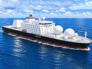
The 124-foot, twin-hull ship will conduct basic hydrographic surveys of the sea floor using side scan and multibeam sonar technologies. The ship is also equipped to deploy buoys and unmanned submersibles and conduct general oceanographic research. Ferdinand R. Hassler is the first SWATH (small waterplane area, twin-hull vesse)l to be constructed for NOAA. The ship’s twin-hull design minimizes the rocking motion caused by wave action, making it particularly suited to mapping the ocean floor.
The new ship’s primary mission will be to detect and monitor changes to the sea floor. Data collected by the ship will be used to update nautical charts, detect potential hazards to navigation, and enhance our understanding of the ever-changing marine environment.
“With the growth in the size of commercial vessels and the importance of waterborne commerce to our economic security, there is a critical need for accurate information about our coastal waterways,” said Kathryn Sullivan, Ph.D., assistant secretary of commerce for environmental observation and prediction. “This advanced NOAA survey vessel will play a vital role in ensuring safe navigation and commerce as we work each and every day to position America for the future.”
Ferdinand R. Hassler will operate mainly along the Atlantic and Gulf coasts, Caribbean Sea and Great Lakes in support of the NOAA Office of Coast Survey’s nautical charting mission.
“NOAA Ship Ferdinand R. Hassler represents a major step forward in NOAA’s effort to modernize the agency’s fleet,” said Rear Adm. Jonathan Bailey, director of the NOAA Office of Marine and Aviation Operations and the NOAA Corps. “This new, highly capable ship will enable surveyors to map waterways and coastal areas both accurately and efficiently.”
NOAA Ship Ferdinand R. Hassler is part of the NOAA fleet of ships and aircraft operated, managed and maintained by NOAA’s Office of Marine and Aviation Operations, which includes both civilians and the commissioned officers of the NOAA Corps, one of the seven uniformed services of the United States. The ship will be homeported in New Castle, N.H.
NOAA’s Office of Coast Survey, originally formed by President Thomas Jefferson in 1807, updates the nation’s nautical charts, surveys the coastal seafloor, responds to maritime emergencies and searches for underwater obstructions and wreckage that pose a danger to navigation.
NOAA’s mission is to understand and predict changes in the Earth’s environment, from the depths of the ocean to the surface of the sun, and to conserve and manage our coastal and marine resources. Join us on Facebook , Twitter and our other social media channels.
Categories: News

Leave a Reply
You must be logged in to post a comment.