![The 52-foot Mirage is the third flagship platform in Saronic’s growing ASV fleet. [Photo: Saronic Technologies]](https://www.marinelog.com/wp-content/uploads/2026/07/smirage-300x225.jpg)
Gulf Coast braces for Barry
Written by Marine Log Staff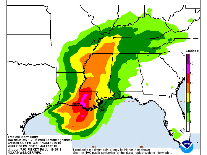
Massive amounts of rainfall are predicted over the next seven days (Graphic released by National Hurricane Center at 4.07 pm CDT, Friday June 12
As Tropical Storm Barry churned through the Gulf of Mexico, offshore oil and gas operators in the Gulf of Mexico evacuated platforms and rigs in response – and ion shore worries mounted about the expected storm surge and dramatic and sustained volumes of rain expected.
As of 11.30 am CDT today, the Bureau of Safety and Environmental Enforcement reported that, personnel had been evacuated from a total of 257 production platforms, 38.42 percent of the 669 manned platforms in the Gulf of Mexico. Personnel have been evacuated from 10 non-DP rigs equivalent to 47.6 percent of the 21 rigs of this type currently operating in the Gulf. Eleven DP rigs had moved out of the storm’s path as a precaution— 55 percent of the 20 DP rigs currently operating in the Gulf.
From operator reports, BSEE estimates that approximately 58.74 percent of the current oil production in the Gulf of Mexico has been shut-in, which equates to 1,110,135 barrels of oil per day. It is also estimated that approximately 48.69 percent of the natural gas production, or 1,353.59 million cubic feet per day in the Gulf of Mexico has been shut-in.
RAINFALL, STORM SURGE
The National Hurricane Center released the following bulletin at 4.00 pm CDT
BULLETIN
Tropical Storm Barry Advisory Number  10
NWS National Hurricane Center Miami FL       AL022019
400 PM CDT Fri Jul 12 2019


...BARRY EXPECTED TO BE A HURRICANE BY LANDFALL ON SATURDAY...
...DANGEROUS STORM SURGE, HEAVY RAINS, AND WIND CONDITIONS
EXPECTED ACROSS THE NORTH-CENTRAL GULF COAST...


SUMMARY OF 400 PM CDT...2100 UTC...INFORMATION
----------------------------------------------
LOCATION...28.7N 90.9W
ABOUT 70 MI...115 KM SSE OF MORGAN CITY LOUISIANA
ABOUT 110 MI...180 KM WSW OF THE MOUTH OF THE MISSISSIPPI RIVER
MAXIMUM SUSTAINED WINDS...65 MPH...100 KM/H
PRESENT MOVEMENT...WNW OR 300 DEGREES AT 6 MPH...9 KM/H
MINIMUM CENTRAL PRESSURE...993 MB...29.33 INCHES


WATCHES AND WARNINGS
--------------------
CHANGES WITH THIS ADVISORY...


None.


SUMMARY OF WATCHES AND WARNINGS IN EFFECT...


A Hurricane Warning is in effect for...
* Intracoastal City to Grand Isle


A Tropical Storm Warning is in effect for...
* Mouth of the Pearl River to Grand Isle
* Lake Pontchartrain and Lake Maurepas including metropolitan New
Orleans
* Intracoastal City to Cameron


A Storm Surge Warning is in effect for...
* Intracoastal City to Biloxi
* Lake Pontchartrain


A Storm Surge Watch is in effect for...
* Biloxi to the Mississippi/Alabama border


A Hurricane Watch is in effect for...
* Mouth of the Mississippi River to Grand Isle
* Intracoastal City to Cameron


A Tropical Storm Watch is in effect for...
* East of the Mouth of the Pearl River to the Mississippi/Alabama
border


A Hurricane Warning means that hurricane conditions are expected
somewhere within the warning area.  A warning is typically issued
36 hours before the anticipated first occurrence of
tropical-storm-force winds, conditions that make outside
preparations difficult or dangerous.  Preparations to protect life
and property should be rushed to completion.


A Tropical Storm Warning means that tropical storm conditions are
expected somewhere within the warning area within 36 hours.


A Storm Surge Warning means there is a danger of life-threatening
inundation from rising water moving inland from the coastline
during the next 36 hours in the indicated locations.  For a
depiction of areas at risk please see the National Weather
Service Storm Surge Watch/Warning Graphic available at
hurricanes.gov.  This is a life-threatening situation.  Persons
located within these areas should take all necessary actions to
protect life and property from rising water and the potential for
other dangerous conditions.  Promptly follow evacuation and other
instructions from local officials.


A Storm Surge Watch means there is a possibility of life-
threatening inundation from rising water moving inland from the
coastline in the indicated locations during the next 48 hours.


A Hurricane Watch means that hurricane conditions are possible
within the watch area.  A watch is typically issued 48 hours
before the anticipated first occurrence of tropical-storm-force
winds conditions that make outside preparations difficult or
dangerous.


A Tropical Storm Watch means that tropical storm conditions are
possible within the watch area generally within 48 hours.


Interests elsewhere along the Gulf Coast from the Upper Texas Coast
to the Florida Panhandle should monitor the progress of this system.


For storm information specific to your area, including possible
inland watches and warnings, please monitor products issued by your
local National Weather Service forecast office.


DISCUSSION AND OUTLOOK
----------------------
At 400 PM CDT (2100 UTC), the center of Tropical Storm Barry was
located near latitude 28.7 North, longitude 90.9 West.  Barry is
moving toward the west-northwest near 6 mph (9 km/h).  A motion
toward the northwest should begin during the next several hours,
followed by a turn toward the north Saturday night or Sunday.  On
the forecast track, the center of Barry will approach the central or
southeastern coast of Louisiana through tonight and then make
landfall over the central Louisiana coast on Saturday.  After
landfall, Barry is expected to move generally northward through the
Mississippi Valley through Sunday night.


Maximum sustained winds are near 65 mph (100 km/h) with higher
gusts.  Strengthening is forecast before landfall, and Barry is
expected to be a hurricane when the center reaches the Louisiana
coast on Saturday.  Weakening is expected after Barry moves inland.


Tropical-storm-force winds extend outward up to 175 miles (280 km)
from the center.  An oil rig located southwest of the Mouth of the
Mississippi River recently reported sustained winds of 74 mph and a
wind gust of 85 mph at an elevation of 295 ft.


The estimated minimum central pressure is 993 mb (29.33 inches).


HAZARDS AFFECTING LAND
----------------------
Key Messages for Barry can be found in the Tropical Cyclone
Discussion under AWIPS header MIATCDAT2 and WMO header WTNT42 KNHC.


STORM SURGE:  The combination of a dangerous storm surge and the
tide will cause normally dry areas near the coast to be flooded by
rising waters moving inland from the shoreline.  The water could
reach the following heights above ground somewhere in the indicated
areas if the peak surge occurs at the time of high tide...


Mouth of the Atchafalaya River to Shell Beach...3 to 6 ft
Shell Beach to Biloxi MS...3 to 5 ft
Intracoastal City to the Mouth of the Atchafalaya River...3 to 5 ft
Lake Pontchartrain...3 to 5 ft
Biloxi MS to the Mississippi/Alabama border...2 to 4 ft
Lake Maurepas...1 to 3 ft


Surge-related flooding depends on the relative timing of the surge
and the tidal cycle, and can vary greatly over short distances. For
information specific to your area, please see products issued by
your local National Weather Service forecast office.


RAINFALL:  Barry is expected to produce total rain accumulations of
10 to 20 inches over south-central and southeast Louisiana and
southwest Mississippi, with isolated maximum amounts of 25 inches.
These rains are expected to lead to dangerous, life threatening
flooding over portions of the central Gulf Coast into the Lower
Mississippi Valley.  Across the remainder of the Lower Mississippi
Valley, total rain accumulations of 4 to 8 inches are expected, with
isolated maximum amounts of 12 inches. By early next week, Barry is
expected to produce rainfall accumulations of 4 to 8 inches across
western portions of the Tennessee Valley.


WIND:  Hurricane conditions are expected in the Hurricane Warning
area tonight or Saturday, with tropical storm conditions currently
spreading across the area.  Hurricane conditions are possible within
the Hurricane Watch area tonight or Saturday morning.  Tropical
storm conditions are occurring across the Tropical Storm Warning
area in southeastern Louisiana at this time.  Tropical storm
conditions are possible in the Tropical Storm Watch area by tonight
or Saturday.  Wind gusts to tropical-storm force in squalls are
possible along portions of the coasts of Alabama and the western
Florida Panhandle through Saturday night.


TORNADOES:  A couple tornadoes are possible late tonight through
Saturday across southeast Louisiana and southern Mississippi.


NEXT ADVISORY
-------------
Next intermediate advisory at 700 PM CDT.
Next complete advisory at 1000 PM CDT.


$$
Forecaster Beven
Categories: News
![USNS William Mclean (T-AKE 12). [U.S. Navy photograph]](https://www.marinelog.com/wp-content/uploads/2026/07/TAKE-12-300x225.jpg)

![Going forward, all operations of the combined operation will be conducted under the Moran Towing Corporation name. [Photo: Moran Towing]](https://www.marinelog.com/wp-content/uploads/2026/07/MichaelS-300x250.jpg)