HawkEye 360 just made it harder for shipping’s bad actors to go dark
Written by Nick Blenkey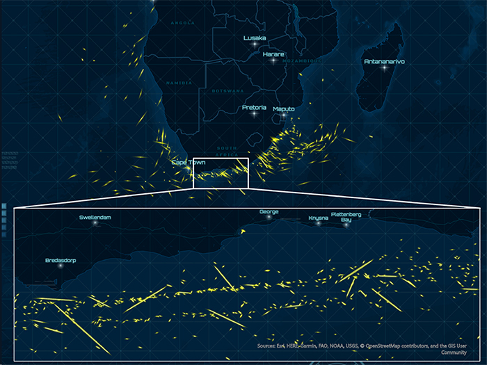
HawkEye 360 geolocates S-band marine navigation radars from vessels off the coast of South Africa [Copyright 2020: HawkEye 360 Inc.
Herndon, Va., headquartered HawkEye 360 Inc. has boosted its vessel monitoring capabilities, making it harder for vessels engaged in dubious activities to go dark by turning off AIS transmissions.
HawkEye 360 Inc. is the first commercial company to use formation flying satellites to create a new class of radio frequency (RF) data and data analytics. Today it announced that its flagship RFGeo product can now map an expanded catalog of marine navigation radar signals to further improve global maritime situational awareness. With this update, HawkEye 360 introduces the first S-band radar signal and quadruples the number of X-band radar signals in the company’s library. HawkEye 360 can now cover the most used frequencies for X-band magnetron-based radar systems, providing a more comprehensive view of maritime activity.
“We’re addressing critical gaps in Maritime Domain Awareness by revealing an entirely new data layer for vessel monitoring,” said John Serafini, Chief Executive Officer, HawkEye 360. “We’re excited to introduce our first signal in the S-band frequencies. By expanding our signal catalog, we’re not just collecting new and diverse RF data sets, we’re providing actionable intelligence to support the increasing number and scale of our customers’ missions.”
Vessels continuously operate marine radars to safely navigate from point to point and avoid nearby obstacles, making them an excellent means to track vessels that have otherwise ceased AIS transmissions and gone dark. Commercial vessels 300 gross tonnage or larger are required to be equipped with X-band radars (9 GHz). The largest vessels also carry S-band radars (3 GHz) to penetrate deeper through rain or fog. Each new signal improves Hawkeye 360’s ability to develop vessel profiles. This data helps clients identify dark vessels that might be involved in illicit activities, such as smuggling, illegal fishing, or sanctions evasion.
“Our customers need to maintain accurate and consistent visibility of vessels,” said Alex Fox, Executive Vice President for Business Development, Sales and Marketing, HawkEye 360. “Vessels are continuing to evade AIS detection to conduct illicit activities, making it difficult for organizations to identify and monitor their behaviors. We’re able to provide unique data sets that enable our customers to keep their finger on the pulse of vessel activity.”
HawkEye 360’s RFGeo identifies and geolocates RF signals collected by HawkEye 360’s proprietary satellite constellation. RFGeo is the first commercially available product offering global spectrum awareness across a broad range of radio signals. In addition to the newly announced signals, RFGeo can independently geolocate marine VHF marine radios, UHF push-to-talk radios, L-band mobile satellite devices, EPIRB marine emergency distress beacons, and vessel Automatic Identification Systems (AIS). HawkEye 360 is continually adding signals to the catalog to broaden the reach of RF identification across land, sea, and air domains.
Categories: News, Safety and Security, Shipping