NTSB determines cause of Bonnie G grounding
Written by Nick Blenkey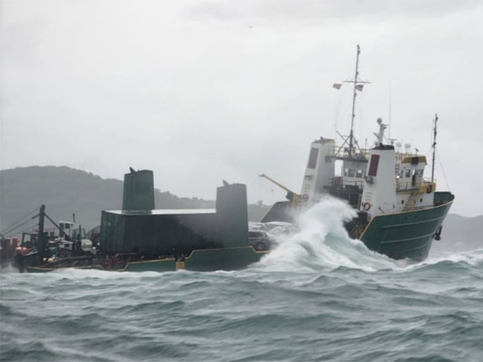
The Bonnie G stranded on rocks following the grounding. [U.S. Coast Guard photograph]
The National Transportation Safety Board has released its report into the October 4, 2023, grounding of the former OSV Bonnie G, half a mile south of the Cyril E. King airport in St. Thomas, U.S. Virgin Islands. The agency finds that an anchor chain failure was the cause of the Bonnie G grounding, which occurred during Tropical Storm Phillippe and started a 26-day salvage saga in the height of the hurricane season.
The 172-foot-long, Vanuatu-flagged vessel was originally delivered as an offshore supply vessel by Halter Marine in Lockport, Louisiana, in 1981 and had several previous names, including Lone Wolf, Century, and Bella. It was acquired by Third Lady, LLC in 2020. It then went through a conversion into a cargo vessel, during which the stern ramp was widened and the twin deck stacks were moved to facilitate roll-on/roll-off cargo and maximize deck space. It regularly transported cargo between Puerto Rico, St. Thomas, and St. Croix, with occasional stops in other U.S. Virgin Islands and British Virgin Islands (BVI) ports.
On October 4, 2023, the Bonnie G was anchored, waiting out poor weather about one mile south of St. Thomas when its anchor chain parted and it began to drift toward land. As the captain attempted to navigate the vessel away from shore, the vessel grounded.
The 12 people on board abandoned the vessel and were rescued by the U.S. Coast Guard. The Bonnie G remained aground for several weeks until salvors could refloat it and tow it to a dock. No injuries or pollution were reported. The vessel was declared a total constructive loss, valued at $1.5 million.
Before departing St. Croix, the captain of the Bonnie G reviewed the weather forecast for the vessel’s intended route to St. Thomas. The winds were forecast to be between 10–15 knots and gusting to 25 knots after midnight, by which time the crew expected to be tied up to the dock. When the vessel arrived in Crown Bay, the winds were higher than what had been forecast. In addition, a loaded barge had broken free of its moorings and was partially blocking Bonnie G’s mooring location. Given that the barge wasblocking the Bonnie G’s docking location, and the worse than expected weather conditions, the captain decided to anchor the vessel until the weather improved.
Once in position within the anchorage, the captain deployed 135 feet of anchor chain, which was likely based on an erroneous assessment of the water depth being 23-26 feet when it was actually 68 feet.
Investigators found the Bonnie G should have let out about 2.5–3.5 times more chain than was deployed. Considering the water depth and windy conditions, the Bonnie G captain did not let out enough chain for a secure anchorage.
“When anchoring a vessel, a length of anchor chain that is five to seven times the water depth (scope, or ratio of anchor chain to water depth) should be used; even more anchor chain should be used in adverse weather,” the report said.
The captain also did not use the available onboard navigational chart to identify a rock nearby, and when maneuvering after the anchor chain failed, he inadvertently steered directly onto the rock and grounded the vessel. As a result, the hull was breached just forward of the engine room. The forward watertight door in the engine room of the Bonnie G was open and not secured before the crew abandoned the vessel. Investigators determined that had the watertight door been shut as required, it is likely that progressive flooding of the engine room and aft spaces would not have occurred, limiting vessel damage.
PROBABLE CAUSE
The National Transportation Safety Board determines that the probable cause of the grounding of the cargo vessel Bonnie G was the inadequate scope of chain deployed when anchoring, which likely led to the anchor chain parting, and the captain not identifying a charted rock and steering the vessel onto it when attempting to maneuver to safe water.
LESSONS LEARNED
Being aware of nearby hazards when anchored :When anchoring, mariners should review navigational charts and other sources of local information, such as the U.S. Coast Pilot, to become familiar with nearby hazards. It is important to have this information available in heavy weather conditions, when there is heightened risk of drifting and crews may need to get a vessel underway on short notice.
- Download the full NTSB report HERE
Categories: News, Safety and Security
![Scillionian IV at the Piriou shipyard in Vietnam. [Photo: Isles of Scilly Steamship Group]](https://www.marinelog.com/wp-content/uploads/2026/07/C439-launching-53-300x225.jpg)
![Sleipnir [Photo: Heerema Marine Contractors]](https://www.marinelog.com/wp-content/uploads/2026/07/sleipniratsea-300x225.jpg)