Study: Maritime traffic up 300% since 1992
Written by Nick Blenkey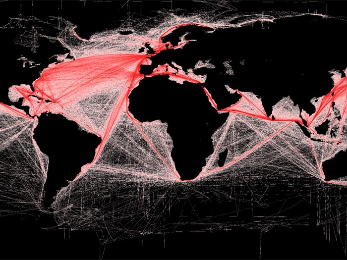
NOVEMBER 18, 2014 — Shipowners still wondering why environmental regulatory pressure on the industry keeps growing might want to take a look at a new study quantifying global ship traffic that has been been accepted for publication in Geophysical Research Letters, a journal of the American Geophysical Union (AGU). It finds that maritime traffic on the world’s oceans has increased four-fold over the past 20 years, likely causing more water, air and noise pollution on the open seas.
The AGU says that the research used satellite data to estimate the number of vessels on the ocean every year between 1992 and 2012. The number of ships traversing the oceans grew by 60 percent between 1992 and 2002. Shipping traffic grew even faster during the second decade of the study, peaking at rate of increase of 10 percent per year in 2011.
Traffic went up in every ocean during the 20 years of the study, except off the coast of Somalia, where increasing piracy has almost completely halted commercial shipping since 2006. In the Indian Ocean, where the world’s busiest shipping lanes are located, ship traffic grew by more than 300 percent over the 20-year period, according to the research.
Ships powered by fossil fuels dump oil, fuel and waste into the water and pump exhaust into the air, says the AGU. Shipping is also a major source of noise pollution, which is increasingly considered potentially harmful to marine mammals, said Jean Tournadre, a geophysicist at Ifremer, the French Institute for the Exploitation of the Sea in Plouzane, and the author of the study, which is entitled “Anthropogenic pressure on the open ocean: the growth of ship traffic revealed by altimeter data analysis.”
“I found it quite worrisome that the ship traffic grew so much, even in very remote regions of the world,” Mr. Tournadre said, “especially when we know that they are the major source of pollution [on the open ocean].”
International trade and the sizes of merchant fleets have both enlarged rapidly over the past two decades, explaining the steep rise in ship traffic, the study reports.
Burgeoning ship traffic has increased the amount of pollution in the atmosphere, particularly above the Sri Lanka-Sumatra-China shipping lane, where the study notes a 50 percent increase in nitrogen dioxide, a common air pollutant, over the 20-year period.
Mr. Tournadre said he hopes the new study will increase scientists’ understanding of how human activities are affecting marine ecosystems and improve models of atmospheric pollution in the open ocean.
The new dataset will provide scientists with invaluable insights into the patterns of ship traffic and the traffic’s effect on the environment, said Batuhan Osmanoglu, a radar systems engineer at NASA’s Goddard Space Flight Center in Green Belt, Md., who was not involved in the study.
“The nice thing about this study is that they have a unique dataset, that maybe we’re looking at for the first time,” he said. “Whenever you have a unique dataset you can quite easily learn something new.”
The new study is claimed to be the first to track ship traffic on a global scale.
The new method outlined in the study uses altimeters aboard satellites to detect the location of ships at sea, in a similar way to how these instruments have been used to track icebergs.
In 2007, Mr. Tournadre was examining satellite data for signs of icebergs in polar seas, when he noticed an odd shape in the data.
“We had some unconventional data in a region, and careful analysis showed us that it was a lighthouse near shipping lanes,” he said. “As we processed the data over the whole globe, we also detected ships.”
Mr. Tournadre found that the altimetry data accurately reproduced known shipping lanes and could be used to estimate the number of vessels on the ocean worldwide. The study used altimetry data from seven different satellites to map ship traffic from 1992 to 2012.
Using satellite data made it possible to calculate ship traffic for the entire globe, whereas AIS records provide relatively limited coverage in both space and time, Mr. Tournadre said. The new method also allowed him to look back at two decades of traffic using archived data, and give independent measurements of ship traffic that were not based on the will or capability of ships to transmit their own positions.
Mr, Tournadre also cautions that some of the growth he has seen in ship traffic could be overestimated because ships, especially containerships, have become larger over the past two decades and possibly easier to detect with altimetry data.
The AGU contact for information on the study is:
Kate Wheeling
+1 (202) 777-7516
kwheeling@agu.org
Categories: Environment


Leave a Reply
You must be logged in to post a comment.