Sitting side by side, the Ports of Long Beach and Los Angeles form the San Pedro Bay Port Complex at the point where the mouth of the Los Angeles River completes its 50-mile course to the Pacific Ocean. Though operating independently, together the two facilities make up the largest port complex in the United States and are responsible for more than 40 percent of the nation’s containerized cargo shipments.
With an eye to the future, the Port of Long Beach is currently involved in a massive, 10-year capital investment program that will cost more than $4.5 billion. According to Randy Parsons, director of security for the Port of Long Beach, “This will enhance our position of being big ship ready. We will be able to provide docking services to ships that can carry cargo up to 21,300 TEU [20-foot equivalent units]. With increasing competition and the growing size of the container ships that are transporting cargo, our expansion program is designed to sustain us as a leader in the industry for the foreseeable future.”
Implementing the Virtual Port
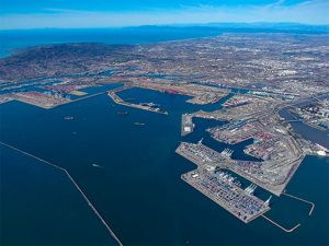
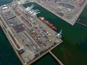
Occupying more than 3,200 acres (13 km2) of land with 25 miles (40 km) of waterfront, the Port of Long Beach poses a major challenge for security operations, particularly since it is an open port that provides docking services to pleasure and small business craft and commercial cargo ships. In addition, more than 15,000 trucks and 100 trains move in and out of the port every day. The dynamic nature of the port, with its constant movement and 24-hour operations, requires close surveillance. Like many ports, Long Beach maintains a multilayered physical security system that includes closed-circuit television surveillance, helicopter downlinks, radar tracking, sonar and other sensor-based systems. About six years ago, Esri ArcGIS was added to help visualize security operations, and the advantages of making GIS central to the port’s joint command and control center were quickly realized.
In 2011, the Port of Long Beach began the development of the Virtual Port application. “Virtual Port is a dynamic, ArcGIS [software]-based system that is fundamental to our security operations,” says Parsons. “It is the essential technology of our command center and has allowed us to geospatially enable our entire security operation. So we now have more than 60 geographically referenced databases that are integrated with the existing elements of our physical security system, which increases exponentially our ability to monitor and analyze our daily operations.”
Additionally, Virtual Port is used for two other primary functions: incident response and business recovery. “The beauty of Virtual Port is that we are using the same ArcGIS platform with the same databases for all three of our main functions,” says Parsons. “This means that our security systems operators have complete familiarity with the system and don’t have to switch over to something else in the event of an emergency.”
A major aspect of business recovery is to get the port operational again as quickly as possible after an incident. Virtual Port can help officials determine which areas of the port are inoperable, what remains open, and what resources are available to quickly resume port operations.
Applying the ArcGIS Platform to Port Security
Virtual Port’s GIS software stack makes full use of the ArcGIS platform. ArcGIS for Server is used to store data layers, services, and feeds within the port’s physical server environment, while Portal for ArcGIS creates, manages, and shares web maps through Virtual Port. This application was built with Esri ArcGIS API for JavaScript and allows users to access Virtual Port from many different environments and devices. Since it is a web app, users do not have to install any native applications or plug-ins to access Virtual Port. Each user is given credentials and a physical or soft token for a two-step authentication. Other software includes ArcGIS GeoEvent Extension for Server, which is used to display dynamic services and feeds, such as asset or automatic identification system vessel tracking. Rule-based alerts are built into GeoEvent Extension and provide instant notifications to port personnel when certain conditions occur, such as a vessel coming within the designated radius of a restricted area. Collector for ArcGIS and Operations Dashboard for ArcGIS are used in Virtual Port to support in-field data collection and situational awareness.
Interagency Collaboration and an Increasing ROI
Partner agencies can connect to Virtual Port and access its common operational picture to collaborate and share information to ensure the resiliency of the facility. Port officials can also run what-if scenarios that model chemical plumes and other hazards to help agencies prepare for and better understand the impact of potentially dangerous situations.
Virtual Port functions as a bidirectional, open-source clearinghouse for the agencies that partner with the security division of the Port of Long Beach. That is, partner agencies have access to the included data, but they are also encouraged to add their own data to the system. About 12 different law enforcement agencies station personnel at the port, and they are allowed access to Virtual Port. To manage the many users, multiple security levels have been implemented. A variety of federal, state, and local public service agencies use some aspect of Virtual Port for their operations. The port also partners with agencies in the surrounding area including the City of Long Beach Emergency Communications and Operations Center, local police and fire departments, and some of the local health agencies.
Though not all ports are the size of the Port of Long Beach or command the resources to implement a GIS-based security system as comprehensive as Virtual Port, Parsons indicates that the system is scalable for different-sized operations. And it can be applied to ports with different cargo operations, such as shipments of break bulk cargo or liquid natural gas. A real win, however, is the recently discovered return on investment (ROI).
“While Virtual Port provides us with a clear operational picture of our extensive day-to-day security activities, we have found that it is also helping lower our business operating costs by streamlining those processes,” concludes Parsons. “This is a huge benefit to centralizing our security operations around ArcGIS because it provides us with an increasing return on investment.”